How successful were this summer’s monsoon forecasts?
Back in mid-April, several agencies made forecasts for how much total rain would fall during the first part of this summer’s monsoon season. Let’s look at how successful these forecasts were. We’ll stick to the May-July period, the first half of summer.
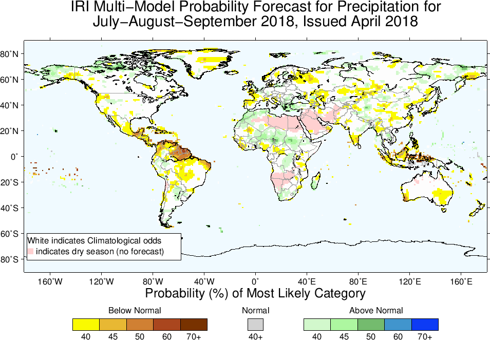
India’s Meteorological Department projected a near-normal monsoon, with 97% of normal rainfall (with a +/- 5% uncertainty range). The IRI at Columbia predicted an enhanced chance of wetter-than-normal conditions over much of South and Southeast Asia, with near-normal rain over most of Africa and dryness over only a few notable regions: Indonesia, the Yucatan Peninsula, and an elongated region over central/western Asia stretching from western China to Turkey and the Mediterranean. They also predicted a moderate chance of dryness over the western US:
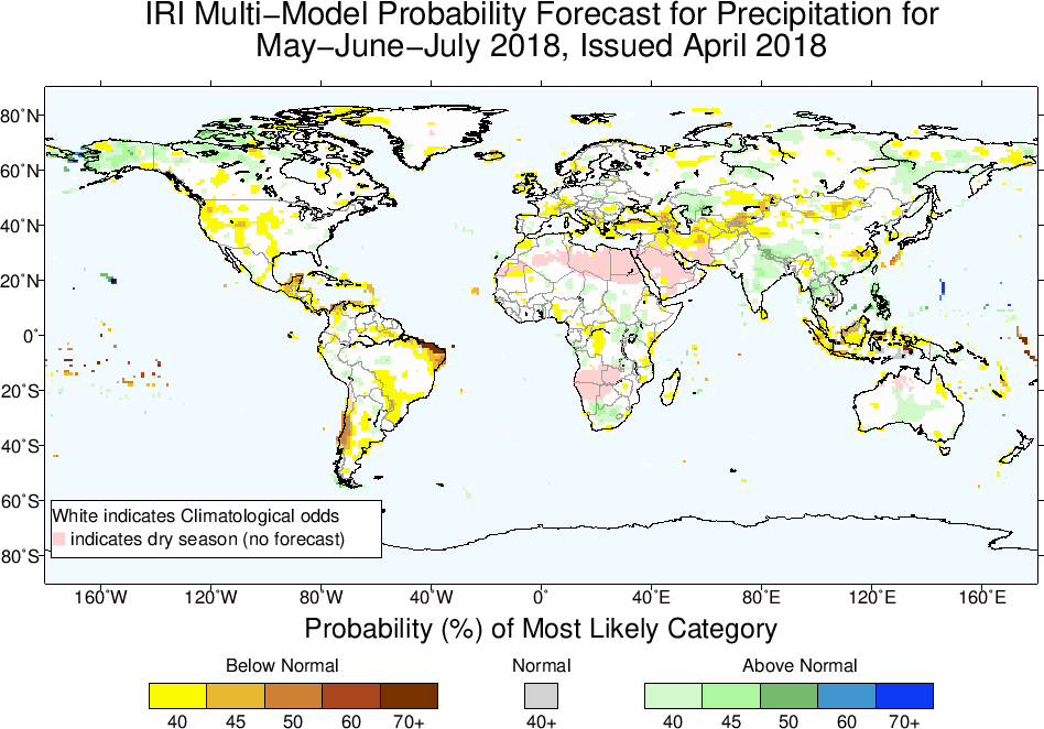
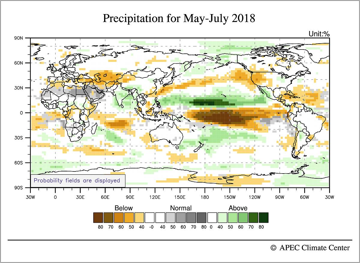
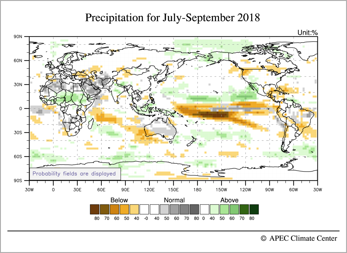
Here’s what actually happened, at least according to one rainfall estimate from NOAA’s CPC: the biggest rainfall anomaly is the very large wet anomaly over Vietnam, Myanmar & Bangladesh (see below graphic, which shows a 3-month period ending in early August instead of end of July because that’s what’s easily on hand). There was flooding in Vietnam, in part due to Tropical Depression Son Tinh, which caused deadly floods and landslides, and in part due to heavy rains in June. A dam collapsed in Laos, flooding displaced 120,000 people in Myanmar, and there were floods and high river levels in Cambodia and Thailand, according to FloodList.com. The seasonal forecasts weren’t wrong in these regions (see the light green shading in the IRI forecast above), but this is a good example of how little information there is in a metric like “40% chance of above normal rainfall in Southeast Asia”. Or, a reminder that “above normal rainfall” could mean torrents. And of course it is also important that most seasonal forecasts are probabilistic, so a single season can’t prove them right or wrong; nevertheless, making these sorts of comparisons is a good way of keeping up with what actually happened in monsoon regions and how forewarned we were.

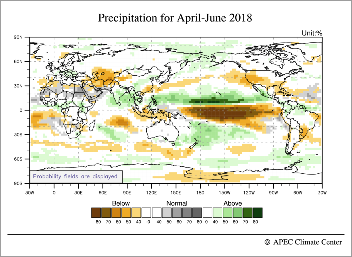
Elsewhere, the Sahel and eastern Africa had a wet early summer, with deadly floods in Algeria, Liberia, Kenya, and other countries, according to articles aggregated by FloodList.com. Such widespread wetness wasn’t predicted in the IRI forecast or the forecast from the APEC Climate Center in Korea (below), and neither was the dryness that occurred in northern South America. The eastern US got a lot of rain, and the western US was near normal (at least according to this precipitation estimate), all in contrast with the seasonal forecasts. The APEC forecast was overall quite similar to that of the IRI in most regions, although it also shows the oceanic rainfall anomalies which provide a useful connection with what’s going on with the global-scale circulation (this is their May-June forecast issued in late-April, 2018):
Since the figure for actual rainfall that we showed above only included land regions, let’s compare this with the observed outgoing longwave radiation (OLR) for May-July (with about a one-week lag again, because it’s what is easily on hand):
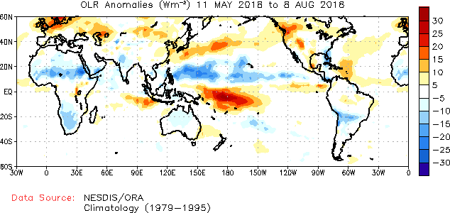
The APEC forecast provides a decent reproduction of the rainfall/convective activity in the Pacific Ocean, with alternating wet and dry bands in the Pacific in roughly the right positions. The extreme wetness of Vietnam and Myanmar don’t show up in the OLR anomaly. In the above OLR map, the western US does look dry, unlike the precipitation anomaly plot shown earlier—although the very active wildfires in parts of the western US would seem to suggest dry conditions, NOAA has said rainfall in the North American monsoon has been normal, and many California reservoirs are near normal (72% to 130% of their historical average).
In summary, the clearest forecast miss, at least in monsoon regions, was in Africa where the Sahel had a wet May-July period that was not forecast by APEC or the IRI. The forecasts of the South Asian monsoon are harder to judge because both positive and negative anomalies exist. India as a whole received below-normal rainfall through the end of July, and has gotten drier since then (the below image is taken from the India Meteorological Department’s website):
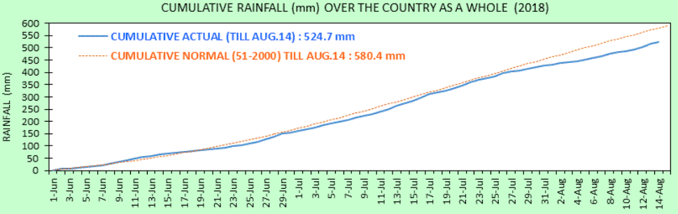
But India is also a sobering example of regional heterogeneity, as it often is: even though the country as a whole is in a nearly 10% deficit compared to a normal monsoon year, the Times of India reported 774 dead from floods. These deaths were spread across the country in seven states. Even though the flooding in Kerala near the southern tip of India has gotten a lot of attention, there were about 170 deaths in the northeast state of West Bengal, 171 deaths in the northern state of Uttar Pradesh (bordering Nepal), and 139 deaths in the central state of Maharashtra. Some of these were caused by floods associated with westward-propagating monsoon lows or depressions. India’s environmental news site Mongabay had an interesting article on the floods and drought that are occurring concurrently in this year’s monsoon.
Group of South Asian nations forecasts normal monsoon
A consensus forecast issued by a group of South Asian countries was just released and projects near-normal monsoon rainfall for summer 2018. The South ASian Climate Outlook Forum (SASCOF) was established in 2010 and met last week, together with experts from both the World Meteorological Organization and user communities in India. They considered dynamical and statistical forecasts issued by all of the world’s major weather prediction centers, and issued this consensus statement:
“Normal rainfall is most likely during the 2018 southwest monsoon season (June – September) over most parts of South Asia. However, above normal rainfall is likely over some areas of east central India and southeastern parts of the region. Below-normal rainfall is likely over some areas of southern, northwestern and northeastern parts of South Asia.”
Visually, here is what this looks like (excerpted from their full forecast discussion):

The APEC climate center in Korea also issued new seasonal forecasts yesterday, which are generally have South Asia being a little wetter than the above consensus forecast, especially during early summer:


Globally, these are similar to the forecasts that APEC released one month ago; if we limit our focus to land regions, a major feature is that North America and southwestern Asia are dry in early summer (through July, while much of the Sahel is wet in late summer. The dryness in southwestern Asia is a big deal because Afghanistan is already in a prolongued drought, with millions of people being food insecure, according to the United Nations. Afghanistan isn’t typically thought of as a monsoon region because it receives most of its rain in winter and is dry in summer, but much of that summer dryness occurs because of the downward atmospheric motion induced over Afghanistan by the South Asian monsoon (e.g. this paper by Bollasina and Nigam).
India issues first monsoon forecast of season; Mexico no longer wet?
India’s first forecast for the 2018 summer monsoon season was just released, and it is for a near-normal amount of rainfall over the country as a whole. In particular, based on their statistical model and their relatively new numerical model, they are predicting 97%±5% of the historical average. More details on the India Met Dept website (find the link in the right-hand bar of scrolling news).
They also cite a ‘low probability’ for deficient rainfall, meaning that there is a 42% chance the rainfall will be in the ‘normal’ range of 96-104% of the long-term average. It’s interesting that their probability breakdown gives a higher probability of low rainfall (44% chance) than of high rainfall (14% chance), but it’s unclear whether their statistical model has enough skill for such subtleties to be meaningful.
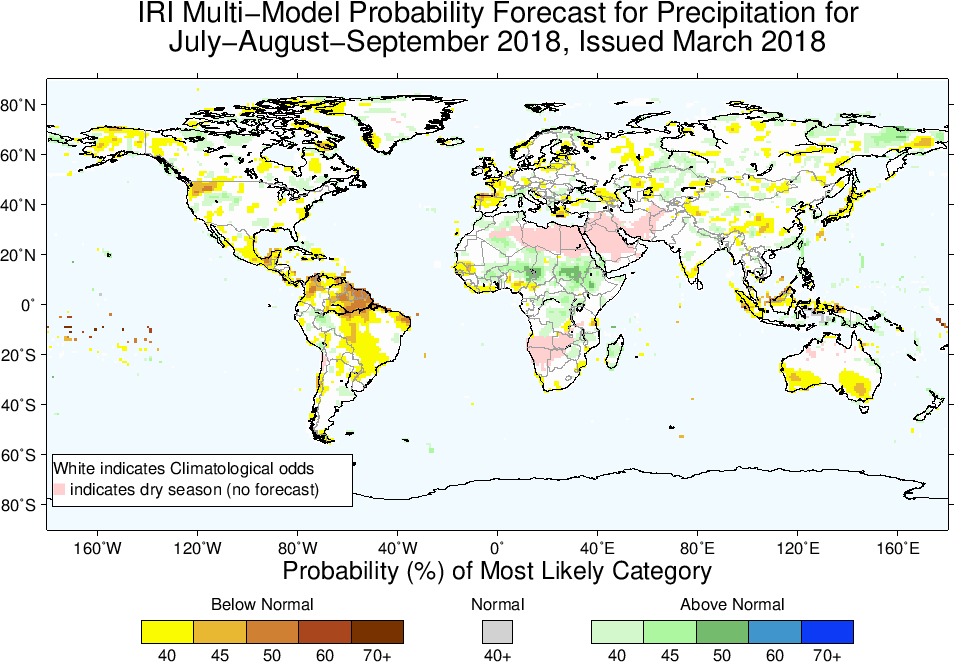
Columbia’s IRI also updated its global seasonal forecast on April 15, and the only notable change for monsoon regions is that Mexico is no longer forecast to be wetter than normal during the spring/early summer. Mexico didn’t have anomalously high rainfall in April thus far, and it doesn’t look like the current weather models are forecasting high rainfall there over the next week, so this actually seems like a change in the spring forecast:

Combined with their July-Sept forecast, this makes it look like India’s country-averaged, seasonal-mean rainfall might indeed be normal, but only because the country will be wet in the northeast during early summer and dry in the south during late summer:
The ENSO forecasts still have La Niña transitioning to a near-neutral ENSO index, but this again is made up of warmer water in the north Pacific and Atlantic, and relatively cold water south of the equator in both of those ocean basins. Given research showing how the tropical rainfall maximum can shift north-south into the hemisphere with the warmer ocean, this helps justify the idea that Africa may be wetter in the northern parts of the Sahel and drier in the south, and that India may also be wetter in the north and drier in the south.
Forecasts of the 2018 summer monsoon
The summer monsoon season will soon be starting in South Asia, northern Africa, and north America, so it’s time to check in with forecasts of seasonal rainfall. India will release its first monsoon forecast in a week or two, and a number of the seasonal forecasts discussed below will be updated in the next week, but it’s nevertheless a good time to take a first look at what might be happening.
IRI/Columbia University is predicting a wet early summer in the Philippines, Southeast Asia, and western Mexico, and a wet late summer in much of Africa (especially East Africa):

The APEC climate center in Korea has many of the same features; because their maps show oceanic rainfall, the wet anomalies over Mexico and the Philippines are more clearly seen as part of a northward shift of the East Pacific ITCZ:
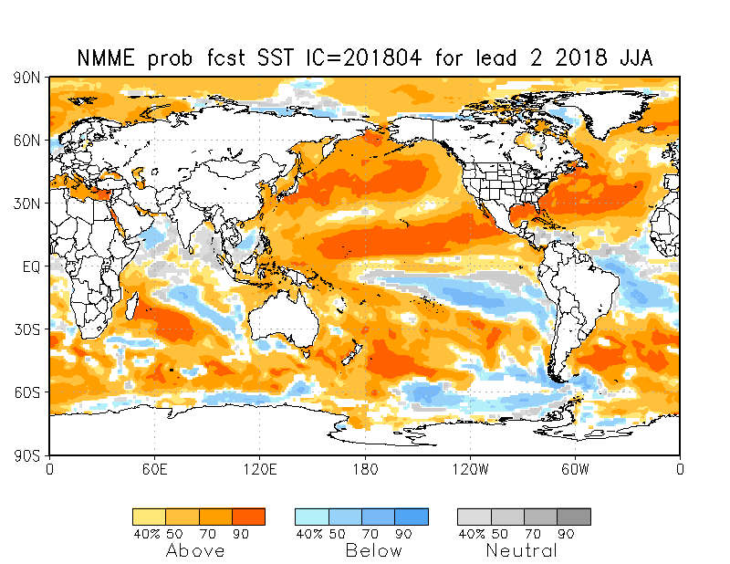
This northward shift of the East Pacific ITCZ isn’t a classic La Niña pattern. Most of the models are actually forecasting a transition from La Niña to El Niño during summer, but this seems to occur with the cold SST persisting south of the equator in the East Pacific while the northeast Pacific warms, producing that northward shift in the ITCZ that may bring wetness to Mexico, the Philippines (and maybe even SE Asia?). Here are the SST forecasts from the North American Multi Model Ensemble:


The Australian BoM provides a nice overview of all the large-scale climate modes: ENSO is nearing neutral, as is the Indian Ocean Dipole. The BoM model is predicting a negative IOD during June (i.e. cooler SST in the western Indian ocean relative to the east), but there seems to be a fair amount of disagreement in models on this — the NMME forecast shown above looks to be a near neutral for JJA, while even the BoM page shows that only 2 out of 6 models forecast a clear negative IOD phase for June.
Links to the forecasts discussed above:
http://www.bom.gov.au/climate/outlooks/#/overview/influences
http://www.bom.gov.au/climate/enso/#tabs=Indian-Ocean
http://www.apcc21.org/ser/outlook.do?lang=en
https://iri.columbia.edu/our-expertise/climate/forecasts/seasonal-climate-forecasts/
 Monsoon news from Google
- Airborne observations of Asian monsoon sees ozone-depleting substances lofting into the stratosphere - Phys.org
- Jinkx Monsoon and Cole Escola on the Business of Being Funny - vmagazine.com
- Monsoons launch ozone-depleting substances into the stratosphere - Earth.com
- Things to do in Goa in monsoon to make the most out of your trip - Business Insider India
- WASA seeks funds before monsoon - The Express Tribune
- Pre Monsoon Rain-Thundershower Over Punjab, Haryana, Chandigarh, Delhi, Rajasthan, Madhya Pradesh: Hailstorm ... - Skymet Weather