Home » Uncategorized
Category Archives: Uncategorized
Afghanistan: deadly floods after years of drought
by William Boos
In a country whose name has become synonymous with generations of war, the past year has been marked by multiple climate catastrophes. First, drought brought a massive food crisis to over 10 million people, stunting the growth of about 40% of children under 6 years of age, and forcing hundreds of thousands of people out of their homes. Then too much water arrived in early 2019, with heavy snow blocking passage between regions and intense rainfall destroying homes and killing at least 63 people.
Afghanistan lies only a bit northwest of India, but unlike that monsoonal nation it receives most of its water in winter. In summer, the heavy rainfall over India and Bangladesh excites a continental-scale atmospheric wave that causes dry air to descend over Afghanistan and much of Pakistan. Afghanistan’s water arrives when the strong midlatitude jet stream hits the western edge of the Tibetan Plateau in winter, causing water to condense and precipitate as it rises over the mountainous terrain. But in late 2017, only a bit of precipitation fell when the wet season should have started, and by the end of that winter less than half of the normal water had been received. The following summer was even drier than usual, and the dryness continued through the end of 2018.
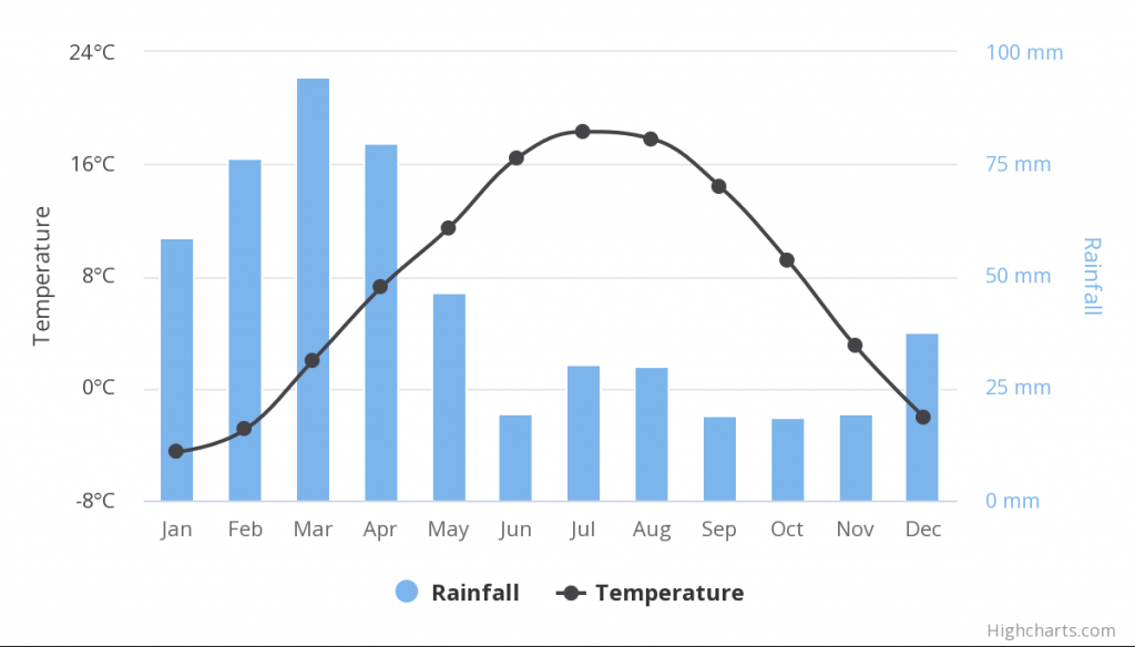
Afghanistan is a nation of farmers, with about 80% of its population making its living through agriculture, so drought can be particularly devastating. Not only is locally grown food destroyed by hydrological extremes, but the economic activity that would allow people to purchase imported food is also compromised. In the 2017-2018 drought, over 90% of farmers reported having insufficient or even no seed to sow in the planting season. The United Nations Food & Agriculture Organization classified 11 million people as being severely food insecure, with 2 million children under the age of five being acutely malnourished.

After more than a year of severe drought, the snow and rain began to fall in early 2019. It took until early February for the region to catch up to its normal amount of water accumulation, but then the water continued to come. Now, in early April 2019, almost 50% more precipitation has fallen than the long-term historical average for this time of year. After the worst drought in decades, torrential rains killed planted seeds and flash floods swept away people driving in cars; over 12,000 homes were damaged or destroyed by floods.
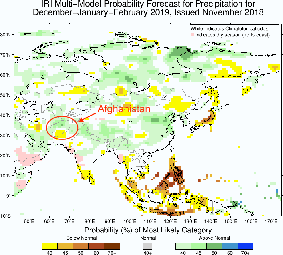
Why the drought and subsequent floods? El Niño (and its sister La Niña) may be to blame. The waters of the eastern equatorial Pacific cooled in autumn of 2017 as a La Niña episode emerged and persisted through spring of 2018, spanning Afghanistan’s rainy season. Southwest Asia tends to be dry during La Niña winters, seemingly due to changes in the jet stream in that region; it also tends to be wet during El Niño winters (when the eastern equatorial Pacific is warm instead of cold). With an El Niño event emerging in fall 2018, the too-wet rainy season we are seeing now fits the pattern well. Indeed, a wet rainy season for Afghanistan was projected in the seasonal forecast that was issued in November of 2018 by the IRI at the Lamont-Doherty Earth Observatory (see figure below).

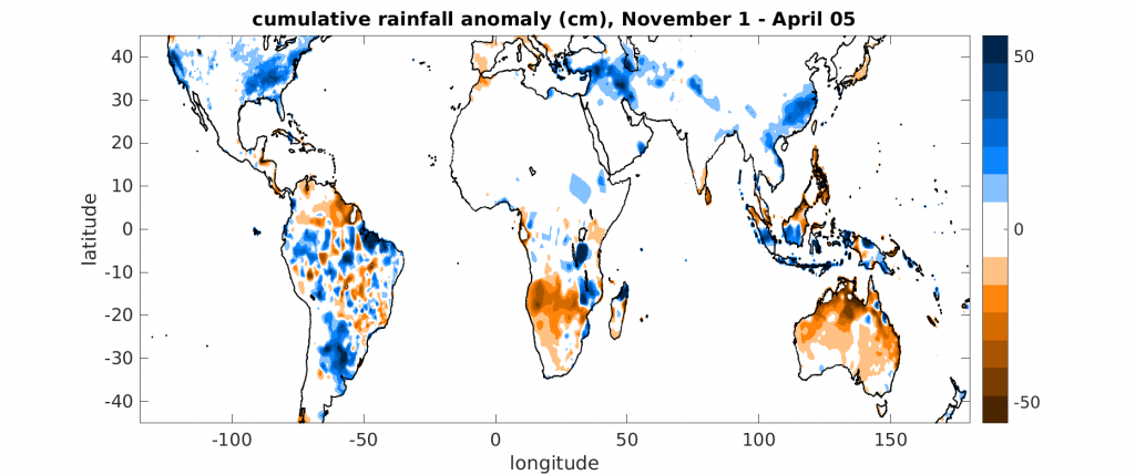
El Niño seems remarkably relevant for the global pattern of flood and drought that has occurred this winter. Australia, southern Africa, and northern South America are dry (see orange regions in below plot), as is typical for an El Niño year (see blue regions two plots prior, which show where rainfall is negatively correlated with the Niño-3.4 index). Eastern China, southwestern Asia, the southeastern U.S., and southeastern South America are wet (blue regions in below plot), which also match the typical El Niño impacts. Of course, the current wet and dry regions don’t match the historical impact patterns exactly, but once you knew El Niño had arrived this past fall, you would have done pretty well if you just used the historical anomaly maps to predict rough regions on the planet that would be abnormally wet or dry.
How will Afghanistan fare in coming months? The IRI forecast includes continued wet weather this spring and early summer, part of a broader pattern of wetness across southwestern Asia. This brings hope for the future, with projections of the wheat harvest being optimistic and rangeland conditions for livestock expected to improve. The Famine Early Warning System Network reports that agricultural labor opportunities have improved some since the drought. But the benefits of this spring’s abundant water supply seem to still lie mostly in the realm of future potential rather than current reality: agricultural labor opportunities, though improved, remain below-average, and non-agricultural labor opportunities also remain below-average. Wages are unchanged and livestock prices are low. Any improvements, furthermore, must contend with the background of armed conflict in the region.

References
http://fews.net/central-asia/afghanistan
How successful were this summer’s monsoon forecasts?
Back in mid-April, several agencies made forecasts for how much total rain would fall during the first part of this summer’s monsoon season. Let’s look at how successful these forecasts were. We’ll stick to the May-July period, the first half of summer.
India’s Meteorological Department projected a near-normal monsoon, with 97% of normal rainfall (with a +/- 5% uncertainty range). The IRI at Columbia predicted an enhanced chance of wetter-than-normal conditions over much of South and Southeast Asia, with near-normal rain over most of Africa and dryness over only a few notable regions: Indonesia, the Yucatan Peninsula, and an elongated region over central/western Asia stretching from western China to Turkey and the Mediterranean. They also predicted a moderate chance of dryness over the western US:
Here’s what actually happened, at least according to one rainfall estimate from NOAA’s CPC: the biggest rainfall anomaly is the very large wet anomaly over Vietnam, Myanmar & Bangladesh (see below graphic, which shows a 3-month period ending in early August instead of end of July because that’s what’s easily on hand). There was flooding in Vietnam, in part due to Tropical Depression Son Tinh, which caused deadly floods and landslides, and in part due to heavy rains in June. A dam collapsed in Laos, flooding displaced 120,000 people in Myanmar, and there were floods and high river levels in Cambodia and Thailand, according to FloodList.com. The seasonal forecasts weren’t wrong in these regions (see the light green shading in the IRI forecast above), but this is a good example of how little information there is in a metric like “40% chance of above normal rainfall in Southeast Asia”. Or, a reminder that “above normal rainfall” could mean torrents. And of course it is also important that most seasonal forecasts are probabilistic, so a single season can’t prove them right or wrong; nevertheless, making these sorts of comparisons is a good way of keeping up with what actually happened in monsoon regions and how forewarned we were.

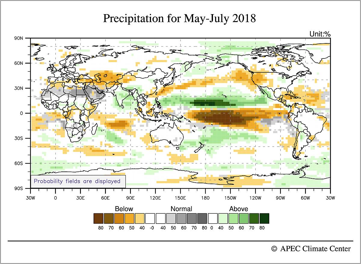
Elsewhere, the Sahel and eastern Africa had a wet early summer, with deadly floods in Algeria, Liberia, Kenya, and other countries, according to articles aggregated by FloodList.com. Such widespread wetness wasn’t predicted in the IRI forecast or the forecast from the APEC Climate Center in Korea (below), and neither was the dryness that occurred in northern South America. The eastern US got a lot of rain, and the western US was near normal (at least according to this precipitation estimate), all in contrast with the seasonal forecasts. The APEC forecast was overall quite similar to that of the IRI in most regions, although it also shows the oceanic rainfall anomalies which provide a useful connection with what’s going on with the global-scale circulation (this is their May-June forecast issued in late-April, 2018):
Since the figure for actual rainfall that we showed above only included land regions, let’s compare this with the observed outgoing longwave radiation (OLR) for May-July (with about a one-week lag again, because it’s what is easily on hand):
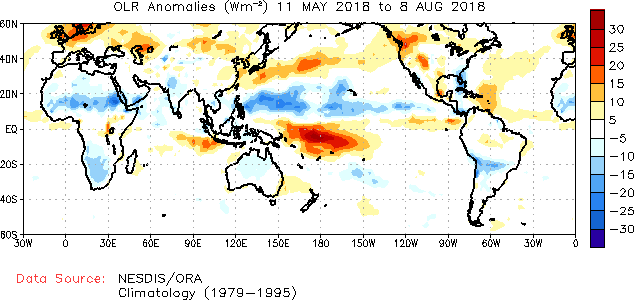
The APEC forecast provides a decent reproduction of the rainfall/convective activity in the Pacific Ocean, with alternating wet and dry bands in the Pacific in roughly the right positions. The extreme wetness of Vietnam and Myanmar don’t show up in the OLR anomaly. In the above OLR map, the western US does look dry, unlike the precipitation anomaly plot shown earlier—although the very active wildfires in parts of the western US would seem to suggest dry conditions, NOAA has said rainfall in the North American monsoon has been normal, and many California reservoirs are near normal (72% to 130% of their historical average).
In summary, the clearest forecast miss, at least in monsoon regions, was in Africa where the Sahel had a wet May-July period that was not forecast by APEC or the IRI. The forecasts of the South Asian monsoon are harder to judge because both positive and negative anomalies exist. India as a whole received below-normal rainfall through the end of July, and has gotten drier since then (the below image is taken from the India Meteorological Department’s website):
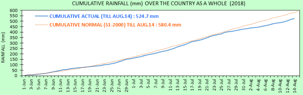
But India is also a sobering example of regional heterogeneity, as it often is: even though the country as a whole is in a nearly 10% deficit compared to a normal monsoon year, the Times of India reported 774 dead from floods. These deaths were spread across the country in seven states. Even though the flooding in Kerala near the southern tip of India has gotten a lot of attention, there were about 170 deaths in the northeast state of West Bengal, 171 deaths in the northern state of Uttar Pradesh (bordering Nepal), and 139 deaths in the central state of Maharashtra. Some of these were caused by floods associated with westward-propagating monsoon lows or depressions. India’s environmental news site Mongabay had an interesting article on the floods and drought that are occurring concurrently in this year’s monsoon.
Group of South Asian nations forecasts normal monsoon
A consensus forecast issued by a group of South Asian countries was just released and projects near-normal monsoon rainfall for summer 2018. The South ASian Climate Outlook Forum (SASCOF) was established in 2010 and met last week, together with experts from both the World Meteorological Organization and user communities in India. They considered dynamical and statistical forecasts issued by all of the world’s major weather prediction centers, and issued this consensus statement:
“Normal rainfall is most likely during the 2018 southwest monsoon season (June – September) over most parts of South Asia. However, above normal rainfall is likely over some areas of east central India and southeastern parts of the region. Below-normal rainfall is likely over some areas of southern, northwestern and northeastern parts of South Asia.”
Visually, here is what this looks like (excerpted from their full forecast discussion):

The APEC climate center in Korea also issued new seasonal forecasts yesterday, which are generally have South Asia being a little wetter than the above consensus forecast, especially during early summer:


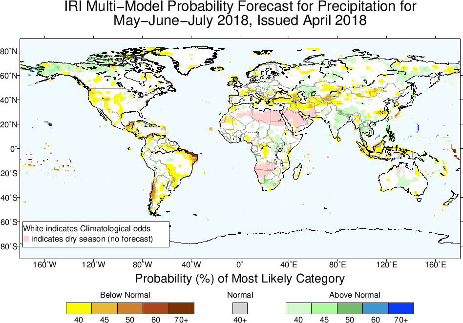
Globally, these are similar to the forecasts that APEC released one month ago; if we limit our focus to land regions, a major feature is that North America and southwestern Asia are dry in early summer (through July, while much of the Sahel is wet in late summer. The dryness in southwestern Asia is a big deal because Afghanistan is already in a prolongued drought, with millions of people being food insecure, according to the United Nations. Afghanistan isn’t typically thought of as a monsoon region because it receives most of its rain in winter and is dry in summer, but much of that summer dryness occurs because of the downward atmospheric motion induced over Afghanistan by the South Asian monsoon (e.g. this paper by Bollasina and Nigam).
 Monsoon news from Google
- Immerse in Mumbai's monsoon magic with this travel guide - NewsBytes
- 4. DAE Monsoon Moisture Hair Mask - Madison.com
- 4. DAE Monsoon Moisture Hair Mask | Shareable Stories | applevalleynewsnow.com - AppleValleyNewsNow.com
- Mumbai civic body prunes 22,334 trees in pre-monsoon drive - India Today
- Pre-monsoon havoc: One dead, widespread infra damage in Nagaland - Morung Express
- Call for action to avert monsoon flooding in Pindi - The Express Tribune