The precipitation anomalies that began this summer’s monsoon season have mostly persisted: a large dry anomaly over central and northern India and a band of dryness over northeast coastal China and the Korean peninsula. These can be seen in maps of anomalous precipitation over the past 30 days:
These dry anomalies seem to be predominantly part of a spatial shift in the normal maximum, from India toward the east over Bangladesh and Myanmar, and from the Korean peninsula toward the south. Although India does not seem to be in a formal “drought” yet, there are widespread reports of impacts from high temperatures and dryness over much of the region, with some large-scale economic effects. North Korea does seem to be in a severe drought state, with media reporting the driest conditions in over a decade and deleterious effects on agriculture.
What has caused these dry conditions? Is the dryness in Korea and India related, or is it just a coincidence that the normal rainfall maximum have shifted eastward over South Asia and southward over East Asia? While it is not possible to answer these questions definitively without much more detailed investigation than I can do on a blog, it is intriguing that sea surface temperatures (SSTs) are warmer than usual over the tropical West Pacific:
In the above map of SST anomalies for the past month, you can see warm anomalies in the equatorial East Pacific associated with what might be the development of an El Nino event, as well as warm anomalies of about 1 K in the West Pacific. Perhaps the warm West Pacific is essentially causing an eastward shift of the South Asian rainfall maximum and a southward shift of the East Asian maximum. The latter is organized in what is called the Maiyu-Baiu front, an east-west band of precipitation that stretches from China to the east of Japan, and this band seems to be shifted south of its normal position so that it now lies more over the cold SST anomalies just south of Japan. So an auxiliary question is: are the cold SSTs a response to the cloudiness of the shifted Maiyu-Baiu front, or is the front responding to the SST anomalies? There has been some research into connections between this front and SST, although I am not very familiar with this and there seem to be many open questions. Or perhaps the cause of the Asian rainfall anomalies is the warm SST in the equatorial East Pacific, or something altogether different from SST.
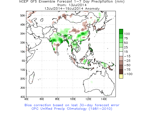
It will be interesting to see if some of these precipitation anomalies continue, especially if we head further toward an El Nino state. Current predictions from the Indian Institute of Tropical Meteorology are for enhanced monsoon rainfall over central and northern India in the coming week or so, with the west part of India remaining dry for the next two weeks. The U.S. forecast model (NCEP’s GFS) is also predicting above-normal rain over central India over the next week, but continued dryness over N. and S. Korea:
Let’s check back in a week or two to see what has happened with Indian and Korean drought.


