Tropical-midlatitude-topographic interactions in Hudhud
(written Oct. 12) Tropical cyclone Hudhud is heading into a storm: a vigorous midlatitude upper-level trough approaching from the west.
In Figure 1, Hudhud is over India while the trough is a kink in the black 200 hPa height contours and the associated ball of cyclonic vorticity (red). They are forecast to “collide” Oct 14th over the Himalayan foothills.
Cumulative rain in the 0.5-degree GFS forecast (Fig. 2) reaches almost 200mm in western Nepal — comparable to amounts seen in the developing winter monsoon in Malaysia, Sumatra, and (to a lesser extent) Vietnam. The initially sharp trough seems to be blunted with time. But locally, valley by valley, there could be more. And the model could be wrong of course.
(Meanwhile, Japan will be under formidable typhoon Vongfong, also interacting with a broader trough in the westerly jet stream)
Animations of Fig. 1 can be seen at http://weather.rsmas.miami.edu/repository/alias/MiamiMonsoonLoops
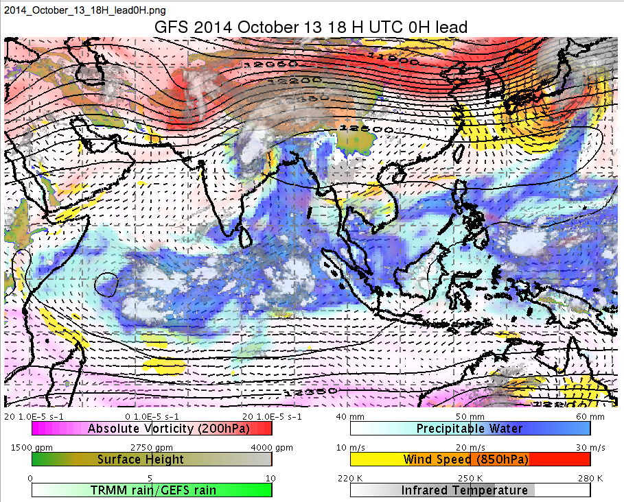
- Fig. 1. The GFS-analyzed situation (plus IR satellite cloudiness) at 18 UTC on Oct. 13 as tropical cyclone Hudhud approaches a strong midlatitude trough over northern India.

- Figure 2: Cumulative rainfall (mm) during Hudhud’s demise, in the GFS 0.5 degree forecast. Vectors at 850 hPa and height contours at 250 hPa are also shown.
 Monsoon news from Google
- Stronger monsoon winds bringing more rainfall to arid regions of north-west India: Southampton varsity study - BusinessLine
- 2024 monsoon broke rainfall, temperature records, PMD says - Aaj News
- Monsoon tips for Women - The Hans India
- More cruise ships dock in Singapore than Hong Kong in July-August during monsoon season, Kai Tak underuse cited - Dimsum Daily
- PMD releases detailed report on 2024 monsoon season - The Nation
- As monsoon disease risks abound, TN health experts urge care - DTNEXT